When you book a drone survey you expect precise data — accurate maps, clean 3D models, and measurements you can trust. But what happens when something far beyond the city skyline interferes with that precision? This week, a massive solar flare sent charged particles racing toward Earth, shaking up GPS signals across the U.S. It’s a rare reminder that even high-tech surveying depends on forces we can’t control.
For drone survey crews, this kind of event isn’t just science news — it’s a call to adapt fast. When GNSS (Global Navigation Satellite System) accuracy drops, surveyors shift from full automation to old-school precision. The goal stays the same: reliable results for clients who need solid ground data for construction, design, or property deals.
When Space Weather Meets Land Surveying
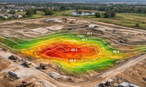
A solar flare sounds like something that only concerns astronomers, but its effects reach every corner of modern life. GPS, cell towers, and even power grids can experience temporary disruptions. In surveying, that means RTK — the real-time kinematic signals that keep drones centimeter-accurate — can drift.
When that happens, Houston’s skies may still be clear, but survey crews notice right away. Fix times get longer. Altitude readings jump slightly. Drone flight paths start needing more manual checks. It’s not a full system failure, but it’s enough to throw off a property line or grading plan if no one’s watching carefully.
That’s why professional survey teams treat solar storms as more than background noise. Every mission starts with signal checks and GNSS status reports from NOAA’s Space Weather Prediction Center. If the data looks unstable, it’s time to pivot — fast.
The Houston Playbook: When Drones Take a Back Seat

In a city where humidity, construction dust, and radio interference are already challenges, GNSS issues can complicate things further. So, what do Houston drone surveyors actually do when satellite corrections start to drift?
They switch modes.
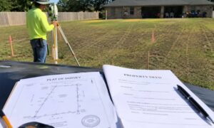
Instead of relying solely on aerial data, crews start blending drone mapping with traditional ground methods. Total stations and GNSS receivers on tripods help verify control points, while extra ground targets ensure the drone data still aligns perfectly when processed later.
In some cases, teams simply wait. A 24-hour delay might seem like an inconvenience, but it’s a smarter move than delivering inaccurate results. Satellite conditions often stabilize quickly, and the extra time allows teams to recheck their base stations and backup data.
The process is a mix of high-tech and human judgment — and that’s what keeps projects moving smoothly even when space weather acts up.
Communication Is the Real Time Saver
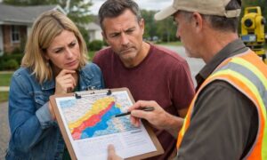
When GNSS interference happens, the key isn’t to rush — it’s to communicate. Surveyors who work with developers, engineers, and lenders know how critical timing is for site planning and loan closings. That’s why Houston crews don’t just adjust in silence; they reach out.
Clients might get a quick call or email: “We’re monitoring today’s solar activity. To keep your data precise, we’re adding control points and rescheduling aerial flights for tomorrow.”
That small update prevents panic later. It turns what could be a frustrating delay into proof of professionalism. In land development, accuracy builds trust — and trust builds long-term relationships.
Why It’s Worth Waiting for Accuracy
A lot of people outside the surveying world assume that once a drone flies, the job’s done. But every project manager or site engineer knows how even a few inches of error can throw off a design. If a solar storm makes a GPS point shift half a foot, a concrete pad or property corner could end up in the wrong spot.
That’s why a short pause during bad GNSS conditions isn’t a setback — it’s protection. Rushing to meet a deadline with unreliable data only leads to rework, permit issues, or costly revisions down the road.
Surveyors who plan around satellite instability aren’t slowing down progress; they’re saving their clients from a much bigger headache later.
A Real Example: Precision Over Pressure
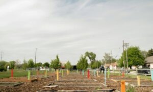
Last year, a Houston drone crew was mapping a 40-acre industrial site near Baytown. Midway through the flight, GNSS accuracy alerts popped up — a solar disturbance was underway. Instead of continuing, the crew paused operations, switched to total station shots for reference, and finished the flight the next morning.
The result? Perfect data alignment, verified control points, and no rework. The client still met their permit deadline — and appreciated the honesty behind the delay.
This story captures what separates seasoned surveyors from hobbyist operators: experience, not just equipment.
Lessons from the Storm
The recent flare is a reminder that even the most advanced tools depend on natural systems that occasionally misbehave. For land surveyors, that means always having a Plan B.
Drone surveys are fast, efficient, and powerful — but the best crews understand when to pause, double-check, and rely on ground truth. That adaptability keeps construction schedules on track and ensures that every map, boundary, or elevation report meets professional standards.
So, the next time space weather makes the headlines, remember: your surveyor is probably checking those same reports — not because they love astronomy, but because your project depends on the precision of satellites 12,000 miles above us.
Final Thoughts
In Houston’s fast-paced development scene, deadlines are tight and accuracy is everything. A drone survey might start in the sky, but its success is built on human skill and decision-making on the ground.
Solar storms come and go, but professional surveyors stay prepared. When signals falter, they adapt, communicate, and protect your project’s integrity. That’s why choosing a certified survey team isn’t just about having the latest drone — it’s about trusting people who know how to handle the unexpected.
Because in the end, it’s not just about flying drones. It’s about knowing when to land them.