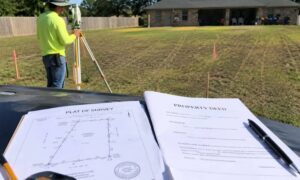
A plat of survey is a drawn map that shows the exact size and shape of a property. A property deed is a written document that proves who owns it. Only a plat of survey shows where your boundary lines physically sit on the ground.
When homeowners need to know where their land starts and ends, most of them pull out two documents. One is the property deed. The other is the plat of survey. Both come up during real estate closings. Both sit in the same folder. But they do very different things. Knowing which one actually shows your lines can save you time, money, and a lot of stress.
What Is a Property Deed?
A property deed is a legal document that transfers ownership of real estate from one person to another. It includes a written description of the land but does not include a map or drawing of the boundary lines.
A property deed is recorded with the Harris County Clerk’s Office after a sale is completed. It becomes part of the public record and proves you are the legal owner of the property.
What many homeowners do not realize is that a deed describes land using words, not pictures. It might say something like “Lot 14, Block 3 of Sunrise Subdivision, according to the plat recorded in Volume 8, Page 42 of the Plat Records of Harris County, Texas.” That language tells an attorney or title company which property you own. It does not tell you where to stand to find your corner marker.
What a Property Deed Does Not Show
- The physical location of boundary lines on the ground
- Corner markers or survey monuments
- Easements that cross the property
- Whether a neighbor’s structure sits on your land
- Setback lines for building or fencing
The Texas Real Estate Commission does not require a new survey for every home sale. Many buyers close on properties using surveys that are 10 to 30 years old. That means some deeds reference surveys that predate major construction, utility work, or storm damage in the area.
What Is a Plat of Survey?
A plat of survey is a scaled drawing made by a licensed land surveyor. It shows the exact boundary lines, dimensions, easements, and improvements on a specific property. In Houston, recorded subdivision plats are filed with the Harris County Clerk and are available to the public.
A plat of survey is the visual document that brings the deed’s written description to life. Where the deed tells you that you own the property, the plat of survey shows you what that property looks like on paper.
There are two types property owners will come across.
Recorded Subdivision Plat
This is created when a developer divides a large piece of land into separate lots. A licensed surveyor draws the plat, the county reviews it, and it gets recorded in the official plat records. Every lot in that subdivision is tied back to this document. Harris County Appraisal District maintains records for more than 2.3 million parcels, and each one traces back to a recorded plat.
Individual Property Survey
This is a survey drawn specifically for one property. It shows the lot boundaries, measured distances, corner monuments, existing structures, and any easements. Lenders and title companies use this type of document during closings.
What a Plat of Survey Contains
- Boundary lines with distances and directions
- Location of corner markers on the ground
- Easements for utilities, drainage, or access
- Existing structures and how close they are to the boundary
- The surveyor’s seal and signature
- Legal description that matches the deed
How Are They Different?
| Feature | Property Deed | Plat of Survey |
| Format | Written document | Scaled map |
| Shows boundary lines visually? | No | Yes |
| Shows easements on a drawing? | No | Yes |
| Proves legal ownership? | Yes | No |
| Prepared by | Attorney or title company | Licensed land surveyor |
| Recorded where in Houston? | Harris County deed records | Harris County plat records |
| Useful for building or disputes? | Limited | Yes |
Which One Actually Shows Your Property Lines?
A plat of survey shows your property lines. A deed only describes them in writing. For homeowners who need to locate boundary lines for building, fencing, or a legal dispute, a current property line survey from a licensed land surveyor is the correct tool.
The deed points you to the plat. The plat shows the design. But even a plat drawn years ago may not reflect what is on the ground today. Survey markers get buried, removed, or shifted during construction and storm events. Houston has seen major flooding events that displaced monuments across entire neighborhoods.
More than 30% of Houston’s land area sits within a federally designated floodplain, according to the Harris County Flood Control District. This makes accurate and current survey records especially important for any property project in the area.
If you need to know exactly where your lines are today, you need a licensed land surveyor to go out and verify the corners in person.
How to Get Your Plat of Survey
Houston-area property owners can find their plat of survey through the Harris County Clerk’s Official Public Records, the Harris County Appraisal District website, or their closing documents from the original home purchase.
Here are the steps to follow:
- Go to hcad.org. Search by your address to find your property’s legal description and lot reference number.
- Visit the Harris County Clerk’s Plat Records. Use the subdivision name or plat volume and page number from your deed to find the recorded plat.
- Check your closing folder. Title companies include a copy of the survey used at closing. Look through your paperwork before spending time on a county search.
- Call your title company. If you have title insurance, the company may have the survey on file and can send you a copy.
- Commission a new survey. If the existing survey is old or missing, contact a licensed land survey company. Only a Registered Professional Land Surveyor, called an RPLS in Texas, can legally establish your boundary lines under Texas Occupations Code Chapter 1071.
Frequently Asked Questions
Is a plat of survey the same as a property deed?
No. A deed transfers and records ownership. A plat of survey is a drawn map that shows the physical boundary lines. They are separate documents with separate purposes.
Can I use my property deed to find my property lines?
Not on your own. A deed uses written legal descriptions that require a licensed land surveyor to translate into physical boundary lines on the ground.
How do I get a plat of survey for my Houston property?
Start with the Harris County Clerk’s plat records or your closing documents. If no current survey is available, hire a licensed land surveyor to prepare a new one.
What is the difference between a plat of survey and a boundary survey?
A plat of survey is the document you receive. A boundary survey is the service the surveyor performs to create it. The boundary survey is the process. The plat of survey is the result.