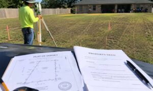
Houston land can trick you. A lot may look flat and ready. The surface feels smooth. Nothing stands out, so it seems safe to build. Then the rain comes. Water starts to sit in one corner. The yard stays wet longer than it should. A driveway slopes the wrong way. These issues don’t come from big hills. They come from small dips that no one noticed early on. Once you look at the lidar mapping insights, those hidden low spots start to show up.
Small Elevation Changes Matter More Than You Think
Houston is mostly flat. Because of that, even tiny changes in height can shift how water moves.
A drop of just a few inches can send water toward a house instead of away from it. Over time, that leads to soggy soil and stress on the foundation.
Most people expect big slopes to cause issues. In Houston, the opposite is often true. The smallest changes create the biggest headaches.
Why These Low Spots Stay Hidden
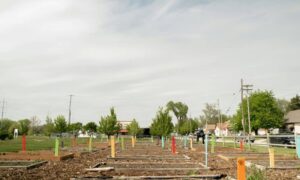
Low spots don’t stand out. They blend into the rest of the lot.
You might walk the site and see nothing wrong. The ground looks even. The grass grows the same across the yard.
But the eye can’t catch slight dips. A two-inch drop across a space is easy to miss. Basic measurements don’t cover every inch either. They give a general idea, not a full picture.
Some lots have also been filled or reshaped in the past. That creates uneven surfaces that are hard to read.
So even experienced builders miss these areas. It’s not about skill. It’s about what you can and can’t see.
How Lidar Mapping Sees What Others Miss
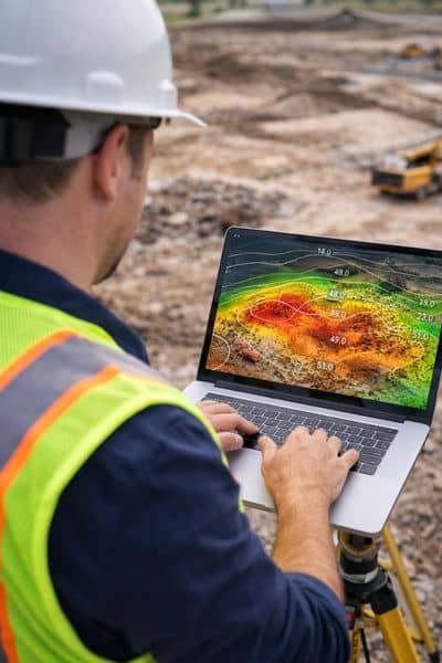
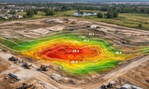
Lidar mapping gives you a clearer way to look at a site.
Instead of checking just a few spots, it covers the whole surface. It picks up thousands of elevation points across the land and turns them into a model you can actually use.
Look at what lidar mapping shows, and the ground starts to make more sense. What seemed flat at first begins to show small dips and slight rises.
You can spot where water will move before anything gets built. That kind of detail is hard to get from basic checks alone.
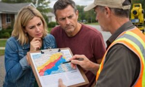
What Builders Notice Once the Data Comes In
When the data shows up, the picture becomes clear.
A yard that looked flat may slope toward the back fence. A corner may sit just low enough to trap water. A driveway area may tilt toward the structure.
These are small details. Yet they change how the site performs.
With lidar mapping, builders don’t have to guess. They can see these issues early and plan around them.
How Early Insight Changes the Plan
Once low spots are clear, the plan can shift before work starts.
Grading can get adjusted. Drainage paths can be improved. Certain areas can be raised or shaped to move water the right way.
These changes don’t take much effort early on. They prevent bigger problems later.
This step keeps the project moving instead of stopping it mid-build.
What Happens When Low Spots Get Ignored
When these small dips go unnoticed, issues show up later.
Water collects near the foundation. Soil stays wet longer than it should. Drainage systems don’t work as planned.
Fixing this after construction starts costs more. Crews may need to regrade the lot. Concrete work may need changes. Landscaping gets redone.
Time gets lost. Budgets stretch. Frustration builds.
All from a small detail that could have been caught early.
Why This Matters More in Houston Projects
Houston sees frequent rain. Even a short storm can move a lot of water across a site.
Because the land is flat, water doesn’t drain quickly on its own. It follows the smallest path available.
That means slight dips control everything.
A small low spot can turn into a standing water issue. A gentle slope can decide where water flows.
That’s why clear elevation data matters so much here.
When Lidar Mapping Makes the Most Sense
Not every site needs the same level of detail. Still, many projects benefit from it.
It helps when working on tight lots. It helps on infill properties where space is limited. It helps when drainage matters from day one.
It also helps when the site has a history of grading or water issues.
In these cases, clear data removes the guesswork.
Better Decisions Start With Better Site Data
Most site problems don’t come from big mistakes. They come from small details that get overlooked.
A slight dip. A subtle slope. A low corner.
These seem minor at first. Yet they affect drainage, stability, and long-term performance.
Lidar mapping brings those details into view.
That early clarity helps builders plan smarter, avoid rework, and keep projects on track.