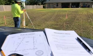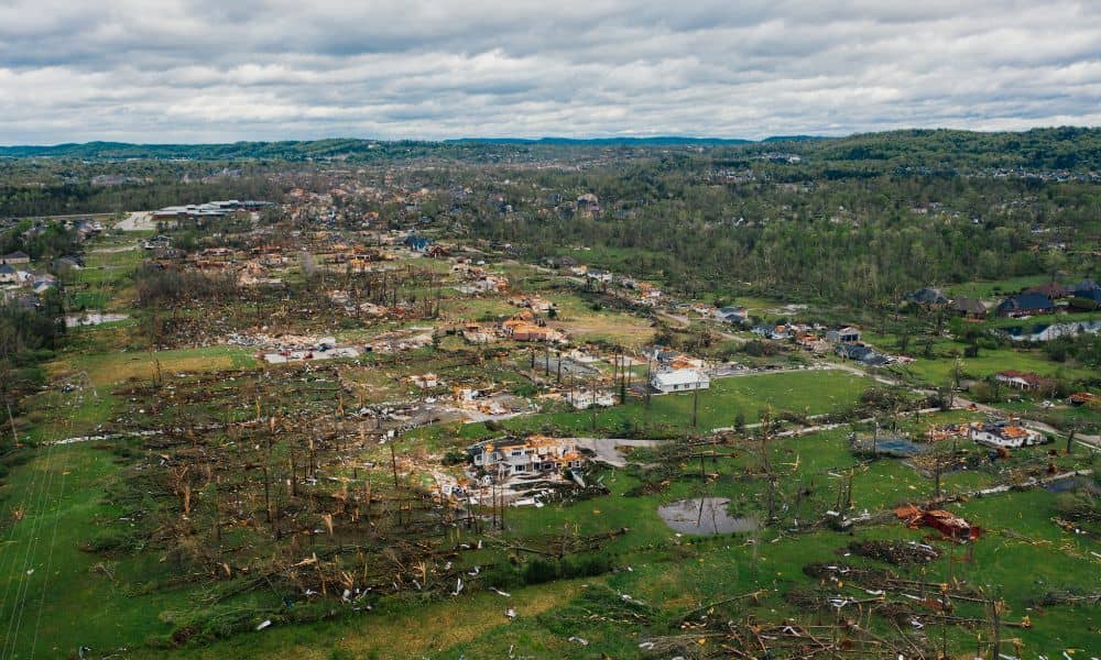
Houston didn’t expect the recent tornadoes, and many developers now see the impact long after the winds stopped. Flood elevation certificates now matter more than ever, especially as FEMA and insurance companies look at how the storm changed local land. Even small shifts in the ground can change how water moves across a property, and that can affect the future of a project. Because of this, developers across the city want new elevation data so they can stay on schedule and avoid problems later.
The tornado hit fast, but the changes it left behind spread across many neighborhoods. The National Weather Service checked damage in the Houston and Galveston areas. Their storm teams found uprooted trees, scattered debris, broken fences, and soil pushed around. These things may look small, yet they can change how water drains after heavy rain. Houston’s flat land already makes drainage tough, and the tornado added new issues that developers cannot ignore.
Storm Damage Creates Hidden Shifts in Elevation
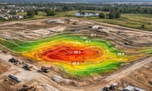
When strong winds pull out trees, the soil underneath rises or sinks. When debris piles up in low spots, the ground forms new high points. And when fences or markers move, they change the way water reaches drains or nearby ditches. These changes create small shifts in elevation, and even a few inches matter in a city that deals with flooding so often. Developers know that tiny changes in height can push a site into a different flood category. That can bring new insurance rules, permit delays, or changes to construction plans.
Because of these risks, many developers want updated elevation data before they move forward. They want to see exactly how the land changed and how those changes affect their next steps.
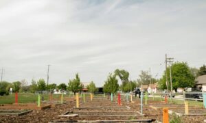
Post-Storm Surveys Reveal New Drainage Paths
Tornado damage can change drainage patterns long before anyone notices. Soil washed into ditches, broken branches blocking culverts, and disturbed ground can all redirect water. These changes don’t always match old plans, and that creates danger for any project already in progress. Developers need new information so they can adjust grading plans, site layouts, or runoff paths before bigger issues appear.
The recent storm pushed more attention toward areas that normally don’t see wind damage. This shift encouraged inspectors and city officials to look at how water now moves through certain communities. After storms like this, FEMA often studies whether flood risk changed. That review can affect whole development zones.
Why Developers Don’t Want to Use Pre-Storm Data
Some developers still hold elevation certificates from past years, but those papers may no longer match what the land looks like today. That difference creates a serious problem. If a lender asks for new flood information and the developer can’t provide it, the loan may get delayed. If an insurance provider requests newer elevation data and the developer can’t show it, the company may raise premiums or require extra steps.
Old elevation data also creates issues during the permit process. Houston often tightens checks after big storms. Reviewers want to confirm that a property still meets drainage rules, flood requirements, and local building codes. A site that passed before the storm might not pass after it. Because of this, developers now update their documents early to avoid delays later.
Tornado Winds Can Move Boundary Evidence Too
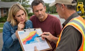
While flooding is the main concern, developers also face another issue: boundary markers that moved during the storm. High winds push fences out of line. Heavy debris crushes temporary stakes. Even small shifts create confusion about where a property begins or ends. Developers now pair boundary checks with new elevation work. They want to avoid arguments with neighbors or city officials during cleanup.
Storm debris also changes the shape of a lot. It fills drains, covers swales, and hides small dips in the land. Many teams bring in surveyors to check the land again and make sure it still matches their plans. They want to find problems early, not when concrete trucks arrive.
FEMA and Insurance Companies Review Data After Major Storms
After big storms, FEMA gathers information about how the land handled the water. If the storm changed runoff or raised flood risk in certain areas, FEMA may update maps. These updates can move properties into higher-risk zones. Developers don’t want surprises, so they gather fresh elevation data now.
Insurance companies also watch storms closely. If they see that a neighborhood struggled with runoff, they may ask for updated elevation information before renewing a policy. Developers expect tighter reviews this year because the tornado affected many parts of Houston. With a new certificate, they can show that their site meets the correct flood elevation and remains safe to build on.
Real Examples Developers Can Relate To
One developer in Cypress planned to start slab work this spring. After the tornado, the team found debris piled in a natural drainage dip. Water now flowed toward the foundation area. A new elevation check helped them catch the issue early and adjust their plan.
Another developer in Spring found that a fallen tree pushed soil toward the neighbor’s yard. That shift changed the edge of the building pad by a few inches. A quick post-storm elevation review saved them from a future permit problem.
And in Midtown, a commercial investor avoided a loan delay by providing an updated flood elevation certificate when the lender asked for proof that the lot still met the base flood rules.
These stories show why new elevation data matters right now. The tornado changed the land in ways no one expected, and those changes affect every stage of a project.
When Developers Should Order a Post-Storm Flood Elevation Certificate
Developers should order a new certificate when:
• the property sits near the tornado’s path • drainage looks different than before • boundary markers moved or disappeared • the project needs lender or insurance approval • building work was planned before the storm
Even if everything looks fine, a new certificate gives peace of mind. It confirms that the project still meets the rules and that hidden storm damage won’t slow things down.
Final Takeaway for Developers
Storms don’t only damage buildings. They change the shape of the land. Small elevation changes can cause big problems during planning, permitting, and insurance review. With a fresh flood elevation certificate, developers protect their timelines, budgets, and progress. Instead of waiting for FEMA updates or insurance questions, they can move forward with confidence.
Houston rebuilds fast. Smart developers prepare even faster. Fresh elevation data helps them stay ahead of new risks and keep their projects moving.