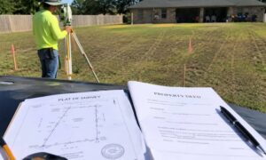
Buying property can feel exciting. You find a great location, the price looks right, and the land seems ready for your plans. However, one hidden problem can quickly change everything: flood risk. Many buyers only think about flooding after they own the land. Yet smart buyers look for these risks before closing the deal. That is why many investors and lenders ask for an accurate ALTA survey for commercial property before a transaction moves forward.
An ALTA survey gives a clear picture of the property. It shows boundaries, easements, and features that could affect how the land can be used. In Houston, it can also help reveal floodplain issues that might not appear in a listing or property brochure.
Because Houston sits near many bayous and drainage areas, this step matters more than many buyers realize.
Why Flood Risk Matters in Houston
Houston receives heavy rain throughout the year. In addition, the city has many bayous and low-lying areas. When storms arrive, water must move somewhere. Because of that, the city relies on drainage channels, floodways, and detention areas to manage stormwater.
Some properties sit close to these systems. Others lie directly inside flood-prone zones. At first glance, the land may look normal. Yet water may flow across the property during major storms.
This situation creates limits on development. For example, builders may need to raise the building pad, change the layout, or leave part of the property untouched.
Therefore, buyers should check flood-related details before finalizing a purchase. In many Houston transactions, this review happens while looking over documents such as an ALTA survey for property due diligence, which can reveal drainage easements or other site conditions that affect how the land can be used.
A Situation Many Houston Buyers Face
Imagine an investor who plans to build a small retail center. The lot sits in a growing part of Houston. The land looks flat, and access to the road looks perfect.
At first, everything seems simple.
However, during the due diligence period, the title company asks for an ALTA survey. The buyer orders the survey, and the surveyor begins reviewing records and measuring the property.
Soon, the survey reveals a drainage easement that crosses part of the land. This easement allows stormwater to move through the property during heavy rain.
Because of this restriction, the developer cannot build over that area.
Now the buyer must adjust the building layout or reduce the project size. Without the survey, the problem may not appear until much later.
What an ALTA Survey Shows About the Land
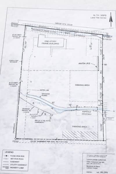
An ALTA survey gives a detailed map of the property. It shows both the legal description and the physical features on the ground.
First, the survey confirms the exact property boundaries. This step ensures the buyer knows the true limits of the land.
Next, it identifies easements. Easements allow utilities, drainage systems, or access routes to cross a property. In Houston, drainage easements appear often because the city must move stormwater safely.
The survey also shows structures, fences, and other improvements. These details help buyers understand how the land currently works.
Most importantly, the survey ties these elements together in one clear document.
Drainage Easements and Why They Matter
Drainage easements play a large role in Houston development. These areas allow water to move during storms.
Because of that purpose, buildings cannot usually sit inside the easement area.
An ALTA survey helps buyers see exactly where these easements lie. It also shows how much land they affect.
Sometimes the easement only touches a small corner. Other times it crosses the middle of the property. When that happens, the usable space may shrink more than expected.
As a result, buyers gain a better understanding of what they can build.
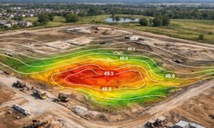
Floodplain Areas and Property Planning
Some Houston properties sit within mapped floodplain zones. These areas carry a higher chance of flooding during severe storms.
Although building in these zones may still be possible, extra rules often apply.
For example, developers may need to elevate buildings or design special drainage systems. These steps increase both time and cost.
An ALTA survey helps show how the property relates to nearby water features and drainage paths. Engineers can then review the site and determine whether construction plans remain practical.
Because this information appears early, buyers can adjust plans before spending large amounts of money.
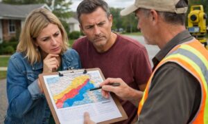
When Survey Findings Change a Deal
Survey results sometimes surprise buyers. However, discovering issues early can actually help the transaction.
First, buyers gain clear information about the property. With accurate details, they can make smarter decisions.
Second, buyers may renegotiate the purchase price if the usable land area turns out smaller than expected.
Third, engineers can redesign the project before construction begins.
Without the survey, the same problems could appear during permitting or construction. At that point, changes become far more expensive.
Properties Where Flood Risks Appear Most Often
Flood-related conditions can appear on many Houston properties. However, some locations show them more frequently.
For example, land near bayous often contains drainage corridors. Older industrial areas may also include historic drainage paths.
Large undeveloped tracts can carry floodplain zones because water must travel across the land during storms.
Redevelopment sites may also contain hidden easements that earlier projects left behind.
Because these conditions vary from property to property, buyers should review each site carefully.
Why Buyers Order an ALTA Survey Early
Many buyers wait until the final stages of a deal to order a survey. However, ordering an ALTA survey earlier often saves time and money.
Early information allows buyers to evaluate risks before investing heavily in design work.
Developers can coordinate with engineers sooner. In addition, lenders and title companies can review the property details without delays.
This approach keeps the project moving smoothly.
Local Knowledge Makes a Big Difference
Survey work requires technical skill. However, local knowledge also plays a key role.
Surveyors familiar with Houston understand common drainage systems and development patterns. They know where flood risks often appear and how local regulations affect projects.
Because of this experience, they can help buyers interpret survey results and understand how the findings affect development plans.
This guidance proves valuable for both investors and property owners.
Final Thoughts
Houston continues to grow quickly. New projects appear across the city every year. Yet the region’s geography means water management will always remain part of property planning.
For that reason, buyers should understand the land before making a purchase.
An ALTA survey helps reveal drainage easements, site conditions, and flood-related restrictions that might otherwise stay hidden.
By reviewing this information early, buyers gain a clear picture of the property. They can then move forward with confidence, knowing the land supports their plans.