Houston has always dealt with heavy rain. However, in recent years, flood risks have grown more serious. New rainfall data, updated flood studies, and ongoing development across Harris County are changing how flood zones get mapped. As a result, projects that once looked safe may now sit closer to flood-prone areas than expected. Because of these shifts, every construction surveyor working in Houston needs to take a closer look at site elevations. More importantly, property owners and builders need to understand why this matters before they pour concrete or move dirt.
Flood maps change. Elevation mistakes last.
Houston’s Floodplain Is Not Static
Houston’s growth has been fast and steady. At the same time, rainfall intensity data has changed. Storm events now bring more water in shorter periods. Therefore, engineers and floodplain managers continue updating models that show where water will go during major storms.
When flood models change, base flood elevations can change too. That means the required finished floor height for a building may increase. In some cases, a property that once sat just outside a flood zone may now fall inside it.
For a developer or homeowner, that can feel confusing. You bought the land based on one set of numbers. Now the rules look different. That’s exactly where a construction surveyor becomes critical.
Why Elevation Matters More Than You Think
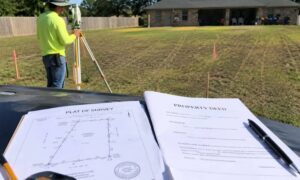
Many people think of a construction survey as marking corners or staking building lines. While that plays a big role, elevation control often carries even more weight in Houston.
Even a few inches can make a major difference.
If a slab sits too low:
- The city may reject the permit.
- Inspectors may delay approvals.
- Flood insurance premiums may rise.
- Future buyers may question compliance.
On the other hand, if you set the slab too high without proper grading adjustments, you may create drainage problems. Water could flow toward neighboring properties. That can trigger complaints or even legal disputes.
Therefore, accurate elevation work protects both your structure and your reputation.
What Has Changed Recently in Houston?
Over the past several years, agencies have studied rainfall data and flood events more closely. Updated storm models show that older standards may not fully reflect today’s risk levels.
Because of that, design professionals now review floodplain boundaries more carefully. Lenders and insurers also pay closer attention to elevation certificates and flood risk details.
As a result, the margin for error has become smaller.
If you rely on old benchmarks or outdated site data, you could base your entire design on numbers that no longer apply. That is why a proactive construction surveyor now reviews vertical control points before construction begins.
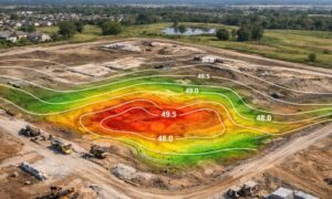
Recalculating Elevations: What It Really Means

Recalculating site elevations does not mean guessing or adding random height. Instead, it means verifying every reference point tied to your project.
First, the surveyor confirms the correct vertical datum. Houston projects commonly rely on NAVD88, but older plans may reference different systems. If those do not match, confusion follows.
Next, the surveyor checks the base flood elevation for the property using the latest available data. Then, they compare that number to the planned finished floor elevation.
If the difference falls too close for comfort, adjustments happen early—before materials arrive and crews mobilize.
Because of that early review, you avoid change orders and delays later.
How This Impacts Builders and Developers
Let’s say you plan to build a commercial warehouse near a bayou. The original design shows the slab set one foot above base flood elevation. However, updated flood studies suggest the required elevation now sits six inches higher.
That six inches matters.
If you ignore it, inspectors may stop the project mid-construction. You would then raise the slab, adjust utilities, and possibly redesign access points. That costs time and money.
On the other hand, if your construction surveyor recalculates elevations at the start, you can update the design before construction begins. The grading plan shifts. The drainage adjusts. The slab height changes. Work flows smoothly.
In Houston’s climate, planning ahead saves more than reacting later.
Rebuilding After Storm Damage
Many property owners rebuild after flood events. In those cases, elevation becomes even more important.
Insurance payouts often depend on compliance with current flood standards. If the rebuilt structure does not meet updated elevation requirements, coverage issues may arise.
Therefore, before rebuilding, owners should ask one simple question:
Have we confirmed the required finished floor elevation under current floodplain data?
A qualified construction surveyor provides that answer with clear documentation.
The Hidden Risk of Outdated Control Points
Construction projects often rely on established control points on-site or nearby. However, if those benchmarks came from older surveys, they may not reflect updated flood modeling or revised datum references.
That mismatch creates risk.
For example, if an engineer designs based on one elevation reference and the contractor builds using another, even small differences multiply across a large site.
Because of that, recalculating elevations includes verifying control points and tying them to reliable, current references.
Consistency across the entire project team matters.
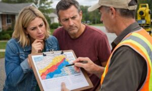
What Property Owners Should Do Now
If you plan to build, expand, or redevelop, take these steps early:
- Confirm the current floodplain status of your property.
- Verify the base flood elevation using updated data.
- Ask how your finished floor elevation compares.
- Ensure your construction surveyor reviews vertical control before foundation work begins.
These actions may seem small. However, they prevent major setbacks later.
Elevation Accuracy Is an Investment, Not an Expense
Some property owners hesitate to spend extra time reviewing elevation data. Yet the cost of recalculation rarely compares to the cost of correction.
Once concrete cures, changes become expensive. Once inspections fail, schedules slip. Once drainage problems appear, repairs disrupt operations.
In contrast, accurate elevation control supports safe construction, smoother permitting, and long-term property value.
Houston will continue to grow. Rainfall patterns may continue to change. Flood models will likely evolve again.
However, one principle stays the same:
Build with accurate data from the start.
Final Thoughts
Houston’s floodplain updates create real impacts for builders and property owners. Although flood maps may shift quietly in the background, their effects reach every slab, pad, and grading plan across the region.
That is why recalculating site elevations now makes sense.
A skilled construction surveyor does more than place stakes in the ground. They protect your project from risk, delay, and costly redesign. In a city where water defines the landscape, precision defines success.
If you plan to build, make elevation verification your first move—not your last correction.