Buying a home or owning land comes with plenty of excitement—and sometimes, a few surprises. One of those surprises can happen when you hire a surveyor and discover the stakes don’t match where you thought your property line was. If your last survey left you scratching your head, you’re not alone. Many homeowners run into this issue, and it usually comes down to one key thing: the difference between survey stakes and a full property line survey.
Stakes Aren’t the Whole Story
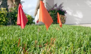
Imagine walking into your backyard and seeing new stakes planted several feet away from where they were the last time. Right away, you wonder: “Did my neighbor move the fence? Did the surveyor make a mistake?” The truth is, survey stakes by themselves are not the final word on your property boundaries.
Stakes are temporary markers. They can shift over time, get knocked out during construction, or even be set differently depending on the type of service you ordered. Without the official drawing, notes, and legal seal that come with a property line survey, stakes can cause more confusion than clarity.
Why Stakes “Move” Over Time
There are several reasons why stakes don’t always line up with past surveys:

- Disturbed monuments: Construction work, landscaping, or heavy flooding can dislodge the original markers surveyors rely on.
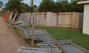
- Fence-line vs. deed-line: In Houston’s packed subdivisions, fences don’t always sit right on the legal boundary. A surveyor may find your deed line doesn’t match where the fence stands.
- New evidence: Sometimes, adjoining properties provide updated records or plats. When surveyors review this information, they might adjust where the true line falls.
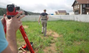
- Updated technology: Survey equipment today, like GPS and drones, can detect differences that older tools missed.
- Stake-only jobs: If you only paid for a staking service in the past, you probably didn’t get a full property line survey. That means the original markers weren’t tied to a legally defensible map.
In short, stakes don’t move on their own—what changes is the evidence, the tools, or the scope of the work.
Houston’s Unique Challenges
Why is this issue especially common in Houston? A few reasons stand out.
First, the city is growing quickly. New subdivisions, infill development, and constant construction put pressure on boundary lines. It’s not unusual for two properties to overlap on paper, even if the fences look fine on the ground.
Second, Houston has long dealt with floodplain concerns. After Hurricane Harvey, homeowners and buyers started paying closer attention to where exactly their property sits. In some neighborhoods, just a few feet difference in grade or location can affect flood insurance requirements. A proper survey helps confirm whether your land needs a FEMA elevation certificate or not.
Finally, public discussion around land surveys is more visible than ever. On local forums and even Reddit, residents debate issues like flood risks, fence disputes, and the reliability of stakes. All of this adds up to one clear message: you can’t afford to rely only on markers in the ground.
The Risk of Stake-Only Services
Stake-only jobs may seem cheaper upfront, but they often create expensive problems later. When a surveyor only places stakes, you don’t get a signed and sealed plat, detailed measurements, or a record of found and set monuments.
If you end up in a boundary dispute, those stakes carry little weight. Courts, lenders, and city offices rely on documented surveys prepared by a licensed surveyor. Without that documentation, you may have to pay for a second survey anyway—sometimes under stressful, time-sensitive circumstances like a real estate closing.
Think of a property line survey as your legal safety net. It’s not just about where the stakes go; it’s about having proof that will stand up if anyone challenges your boundaries.
What to Do When Results Don’t Match
So, what should you do if you notice differences between your current survey and the old stakes? First, don’t panic. It doesn’t always mean your neighbor has claimed part of your yard or that your last surveyor was wrong.
Start by asking your surveyor for an explanation in writing. They should be able to show you what evidence they used—whether that’s deed descriptions, subdivision plats, or monuments in the field. If their reasoning makes sense, you’ll have confidence in the new results.
If the discrepancy is major, consider ordering a new property line survey with full documentation. Yes, it costs more than a stake-out job, but it ensures you have defensible proof of where your land begins and ends.
How Homeowners Can Protect Themselves
You don’t need to become a survey expert to avoid problems, but you do need to know what to ask. When hiring a surveyor, confirm:
- You’ll receive a signed and sealed drawing, not just stakes.
- The surveyor will document monuments they found, set, or replaced.
- Encroachments—like a neighbor’s fence crossing the line—will be noted in the report.
- The survey complies with Texas Board of Professional Land Surveying standards.
These steps help you avoid surprises and give you a clear, legal picture of your property.
Lessons Learned
The Reddit homeowner who discovered their stakes had “moved” was frustrated, but their story highlights an important truth. Stakes by themselves can’t protect you from disputes, mistakes, or misunderstandings. Only a full property line survey can do that.
In Houston, where boundaries are tested every day by growth, construction, and floodplain issues, having the right survey is more than a formality—it’s peace of mind.
Final Thoughts
If your last survey left you with nothing but stakes, it’s time to upgrade. A property line survey gives you more than just lines on paper—it protects your home, your investment, and your future. Don’t rely on fences or guesswork. Rely on certified documentation that stands strong in any situation.