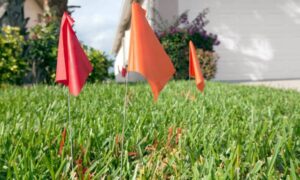
When Houston City Council voted to close part of Polk Street for the huge George R. Brown Convention Center expansion, it might have sounded like a small traffic update. But for downtown property owners, developers, and lenders, that single vote did far more. It changed boundaries, shifted rights-of-way, and started a rush of new ALTA Title Survey requests across Houston’s busy core.
Houston is always changing. New towers rise near Discovery Green and East Downtown (EaDo) every few months. Each project, even a small street closure, can reshape how lots connect, who owns which strip of land, and what easements still exist. These shifts don’t just change maps—they affect loans, construction schedules, and property value.
So why does one road closure matter so much?
When a City Vote Changes Property Lines
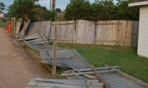
When a city “abandons” a street, that land stops being public property. It often goes back to the owners on each side of it. In this case, closing Polk Street means nearby parcels—some tied to the convention center project—get extra land.
That sounds great, right? More land means more room to build. But it also makes every older survey or title record outdated. The exact boundaries, easements, and legal descriptions have now changed.
That’s where the ALTA Title Survey becomes essential. It’s the standard survey that banks and title insurers trust when property limits or ownership lines shift. Without a new one, no lender or title company will approve a loan, sale, or insurance policy.
Why Developers Need Updated Surveys After Street Abandonment

For developers, the Polk Street decision sets off a chain reaction. New parcels mean new legal descriptions. Those have to appear in updated plats that get recorded with the city’s planning department.
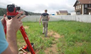
Before that happens, surveyors must confirm what’s actually on the ground—boundaries, easements, and improvements—under the new layout. An ALTA Title Survey clearly shows these details so lenders and title officers can check that the map and the land match.
Houston’s underground system adds another layer. Beneath each street are storm drains, gas lines, cables, and water pipes. When Polk Street’s right-of-way changes, many of those utilities must be mapped again or even moved. A fresh ALTA Title Survey shows where they are and updates the new easement areas.
Skipping this step can lead to big problems—like pouring a foundation over an unmoved pipe or losing access through an easement the city quietly changed.
How the Polk Street Closure Affects More Than One Block
This closure isn’t just about one block. The convention center expansion is part of a long-term downtown plan that includes new hotels, walkways, and mixed-use buildings. Every stage needs grading, staking, and control points built on accurate data.
Surveyors around the George R. Brown area now have more work ahead. They’ll be preparing street-abandonment plats, checking boundaries, and staking new layouts—all of which start with an up-to-date ALTA Title Survey.
Even owners a few blocks away could feel the ripple. If an alley or utility line near their property ties into the abandoned street, lenders might ask for a survey update to prove continued access.
In a fast-growing city like Houston, one council vote can spark months of new surveying and documentation.
The Cost of Using an Outdated Survey
Using an old survey can quietly drain time and money. Picture a lender discovering at the last minute that a boundary on record doesn’t match city files. The deal stops cold until a new survey is complete.
Worse, a title insurer might deny coverage if property details don’t line up. That leaves the owner exposed to future disputes or encroachments.
The better approach is to stay ahead. Order a new ALTA Title Survey as soon as a city project—like a street closure or rezoning—touches your area. It saves stress when financing or permits are due.
Houston’s Ground Conditions Make Precision Vital
Downtown Houston isn’t easy terrain for surveyors. The ground includes layers of old fill, bayou-side soils, and spots slowly sinking from subsidence. These conditions make precise elevation control essential.
A dependable ALTA Title Survey does more than outline boundaries. It sets accurate control points that engineers use for building layouts, grading, and drainage. With new high-rises coming to the convention-center district, accuracy is everything.
Survey crews also work in tight, busy spaces between active sites, sidewalks, and traffic lanes. Using total stations and drones, they gather both surface and elevation data to fit new boundaries neatly into the downtown grid.
What Developers and Property Owners Should Do Now
If your property is near Polk Street, Avenida de las Americas, or Discovery Green, now’s the time to check your survey. Look at its date—if it’s from before the council’s vote, it’s probably outdated.
Contact a licensed land surveyor familiar with street-abandonment work. They can confirm if your lot’s boundaries changed and prepare an updated ALTA Title Survey if needed.
Even if your property isn’t directly touched, it’s smart to review all records. Houston projects, new easements, and underground updates can shift conditions faster than most people realize.
A current ALTA survey gives peace of mind and shows lenders that your title data is accurate. It’s not just paperwork—it’s protection for your investment.
The Bigger Picture:
Houston’s skyline never stops evolving. From light-rail routes to green spaces, every new project redraws lines of access and ownership.
The Polk Street abandonment is one more sign that progress can reshape property overnight. Developers who stay alert and update their ALTA Title Surveys quickly will keep their projects moving and avoid setbacks.
As cranes rise over the convention center, one truth stands firm: every successful downtown project starts with an accurate survey that keeps the city—and its growth—on solid ground.