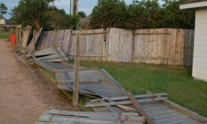
When tornadoes hit Houston, the damage shows up fast—broken roofs, torn fences, uprooted trees, and debris scattered across entire blocks. But what most people don’t see is the hidden impact on the land itself. That’s where lidar mapping comes in. This technology helps surveyors understand what changed on a property after a storm, and right now, it plays a major role in tornado recovery.
In the last few days, tornadoes tore through northwest Houston with winds strong enough to rip buildings apart. Many homeowners feel overwhelmed because cleanup looks urgent, yet rebuilding too soon causes mistakes. Before anyone fixes a fence, levels a yard, or starts major repairs, they need accurate information about the ground. And since storms shift debris, soil, and sometimes even boundary markers, lidar gives surveyors the clearest picture of what really happened.
Understanding Why Tornado Damage Is Complicated
Houston gets heavy storms every year, but tornadoes create a different kind of mess. They scatter debris in all directions and change the landscape in ways that aren’t easy to see with the naked eye. For example, a giant oak tree might fall across two properties. Or, a garage may slide a few inches off its original position. Even a small shift can cause legal or construction problems later.
Because of this, surveyors need tools that show every detail. Traditional fieldwork still helps, yet climbing over debris slows everything down. Also, it’s dangerous. Lidar mapping solves these problems. It uses laser pulses to read the ground—even when the surface looks chaotic. And since it collects millions of data points, surveyors can pinpoint changes that matter for rebuilding.
What Lidar Mapping Actually Shows

Lidar isn’t just a fancy drone photo. It creates a full three-dimensional model of the land. This model shows the height, shape, and position of everything in the scan area. Because of that, lidar does several things extremely well.
It reveals where debris lands, which helps homeowners understand what moved onto their property and what needs to be removed. It shows ground elevation changes, which matter because tornado winds sometimes lower or raise small areas of soil. In Houston, even slight elevation changes affect drainage.
It also helps confirm property lines. After a tornado, some corner markers go missing or get buried. Lidar helps surveyors calculate where those markers should be. And finally, it supports insurance claims because adjusters need proof of storm damage. Lidar gives them detailed visuals and measurements that show the true impact on a property.
Why Lidar Matters in Tornado Zones
Houston has a mix of neighborhoods—some older, some newly developed—and tornado damage affects each one differently. In older subdivisions, fences don’t always follow the true property line. Meanwhile, newer communities often share tight boundary spacing, which creates tension when storm debris crosses from one property to another.
Because of these challenges, lidar helps answer questions like whether a fence fell on your property or the neighbor’s, or if a debris pile blocked a drainage ditch. It can show whether a tornado changed the slope of your yard or if a structure still sits on your lot. These details matter because rebuilding the wrong way causes even more problems. No homeowner wants to replace a fence only to discover later that it sits two feet inside the neighbor’s lot. Clearing debris on a neighbor’s land also creates disputes that are hard to fix once repairs start.
Faster, Safer, and More Accurate Than Old Methods
Before lidar became common, surveyors relied on manual tools to measure storm damage. That approach worked but took more time, especially in dangerous conditions. With debris everywhere, working on foot exposes surveyors to nails, broken lumber, and unstable structures.
Lidar keeps the team safe because drones do most of the heavy lifting. A licensed surveyor still reviews every scan, yet they don’t need to step into unsafe areas. And since drones collect data quickly, large neighborhoods can be mapped in a single day.
Because lidar provides both speed and accuracy, Houston homeowners get answers much sooner. They don’t need to wait weeks to understand the condition of their land. This means repairs move forward faster, and insurance claims become easier to support.
Helping Homeowners Avoid Expensive Mistakes
After a tornado, everyone feels pressure to clean up as fast as possible. Yet rushing creates long-term issues. A homeowner might rebuild a fence in the wrong location. A contractor might grade a yard without checking new elevation changes. Someone might clear debris on a neighbor’s land by mistake. A builder could pour concrete where a drainage swale used to be.
Each mistake leads to disputes, code violations, and extra costs. Lidar prevents these headaches by giving each homeowner a true picture of their land before any repair begins.
Supporting Rebuilds, Insurance Claims, and Permits
The rebuilding process in Houston involves several steps. Insurance companies want proof of storm damage. Contractors need accurate measurements before they start work. And the city often requires documentation for repairs involving structures, driveways, and drainage systems.
Lidar supports all of these needs. It delivers high-resolution elevation models, detailed debris maps, surface and ground models, and measurements needed for accurate site plans. Instead of relying on rough estimates, everyone gets exact information. As a result, the entire recovery process becomes smoother and more predictable.
What to Do if Your Property Was Hit by the Tornado
If your home sits in one of the affected neighborhoods, take a careful approach. Walk the property only if it’s safe, but avoid moving or removing anything major. Many homeowners want to rebuild right away, yet waiting for a professional assessment protects you and your investment.
Before you move forward, it helps to talk with a licensed surveyor near me—the kind of professional most homeowners look for when they need quick, local guidance after a storm. They can tell you if lidar mapping is needed for your property and help you understand what really changed on your land. With clear data and a local expert supporting you, you avoid costly mistakes and step into the rebuilding process with confidence.
Final Thoughts
Tornado damage hits fast, and emotions run high. However, the safest and smartest recovery path starts with accurate land information. Lidar mapping delivers clear, detailed, and reliable data during a time when homeowners need it most. Whether you’re repairing a fence, cleaning debris, or preparing an insurance claim, lidar helps you understand exactly what changed on your land.
If your property was hit by the recent Houston tornadoes, consider getting a professional survey before you rebuild. It’s the best way to protect your home, your safety, and your future plans.