In Houston’s busy property market, one service is quickly becoming the first step for many owners, the topographic survey. This isn’t just a technical drawing; it’s a detailed map that shows the shape of the land, the slope, and key features like trees, fences, and drainage areas.
And in a city where flooding, uneven soil, and strict building rules can cause expensive setbacks, starting with a survey gives you a clear plan from day one. It’s like having a blueprint for avoiding headaches before they start.
What a Topographic Survey Is and Why It Matters in Houston
A topographic survey is essentially a detailed snapshot of your land. It highlights both natural features and man-made structures while showing exactly how high or low different points are.
In Houston, this is especially valuable. Heavy rains are a part of life here, and even small changes in elevation can decide whether water flows away from your home or collects in your yard. That’s why more property owners are making a topographic survey their first step before building, buying, or renovating.
Navigating Houston’s Unique Terrain
Houston might look flat at first glance, but its land hides a lot of variation. Some neighborhoods sit on clay soil that traps water, while others have sandy soil that drains too quickly. Older areas might have uneven grading that sends rainwater in the wrong direction.
A topographic survey reveals these details — the gentle slopes, low areas, and natural drainage paths — so your engineer or architect can design foundations, driveways, and landscaping that work with the land instead of against it.
Meeting Local Permitting Requirements
In many cases, you can’t even apply for certain building permits in Houston without a topographic survey. City and county offices use it to review stormwater plans, check safety measures, and make sure projects meet local regulations.
Having this survey ready before you submit your plans can speed up approval, reduce back-and-forth with the city, and prevent costly mid-project changes.
Helping with Houston’s Flood Risks
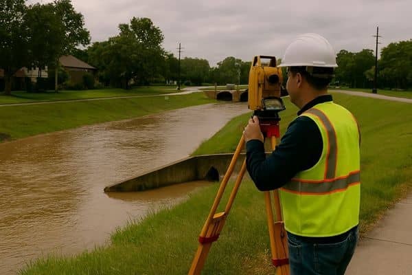
Flooding is one of Houston’s biggest challenges. From heavy rainstorms to hurricane season, water can fill low-lying areas in minutes.
A topographic survey helps you plan for that reality. It shows exactly where water is likely to flow and collect, making it easier to design drainage solutions, elevate building pads, or add landscaping that protects your property. The upfront cost is small compared to the potential savings in flood damage repairs.
Planning Efficient Construction and Landscaping
When builders know the precise elevations of your land, they can place buildings, driveways, and gardens in the best locations. Without that knowledge, it’s easy to make mistakes — like grading a driveway that sends water toward the house or creating a yard that stays muddy for days.
A topographic survey removes the guesswork, ensuring the design is not only attractive but also functional year-round.
Why Landowners Use a Topographic Survey Before Buying
Some of the savviest buyers in Houston order a topographic survey before they even sign the closing papers. That’s because a quick walk-through can’t tell you everything about a property.
A lot might look level, but in reality, it could slope toward a neighbor’s yard, creating future drainage disputes. Knowing this ahead of time gives you leverage — either to negotiate fixes or to reconsider the purchase altogether.
If you’re also unsure about your exact property lines, it’s worth including boundary survey as part of your planning process. This way, you’ll have both the lay of the land and the legal limits before making a final decision.
Avoiding Costly Mistakes
Skipping a topographic survey often means finding problems the hard way — during construction. Fixing them once work has started can blow up your budget and timeline.
Starting with a survey means you’re working with facts, not assumptions. It guides your project from the first sketch to the final build, giving you confidence every step of the way.
The Process of Getting a Topographic Survey in Houston
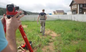
- Hire a licensed local surveyor who knows Houston’s terrain and building codes.
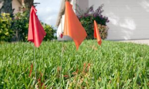
- Site visit and measurements — the surveyor records every elevation point and key feature.
- Detailed mapping — you receive a professional map to share with engineers, architects, and contractors.
Getting the Most Value from Your Survey
Your topographic survey is more than a one-time document. Keep it in your records — it can be reused for future projects like home additions, landscaping redesigns, or drainage upgrades.
Sharing the same survey with every professional involved ensures your whole team works from accurate, consistent information.
Final Thoughts
In Houston, getting a topographic survey early can set the tone for a smooth project. It gives you the facts about your land, helping you plan with accuracy and avoid surprises that cause delays or extra costs.
Working with experienced topographic survey services in Houston means your design, drainage, and permitting decisions are backed by reliable data from day one. For property owners here, that clarity often makes the difference between a plan that works and one that stalls.
FAQs
1. How is a topographic survey different from a boundary survey?
A boundary survey shows property lines. A topographic survey shows the shape, slope, and features of the land. Many Houston owners choose to get both for a complete picture.
2. How long does a topographic survey take?
Most residential lots take a few days. Larger or more complex properties may take longer, especially if recent weather has made the site difficult to access.
3. Do I need a topographic survey if I’m not building?
Yes, in some cases. It’s useful for drainage fixes, landscaping projects, and flood planning. Many buyers also request one before purchasing land.
4. Who can do a topographic survey in Houston?
Only licensed Texas land surveyors can perform this work. They have the tools and knowledge to meet local requirements.
5. Can it help with flooding issues?
Absolutely. The survey shows low spots and water flow paths, helping you design solutions that protect your property during Houston’s heavy rains.