Buying a home is one of the biggest milestones in life. It’s exciting, but it also comes with a long checklist of steps that can feel overwhelming. Among the appraisals, inspections, and mortgage documents, one item you’ll likely come across is the loan closing survey. Many first-time buyers aren’t familiar with it, yet it plays a huge role in protecting your investment.
If you’re purchasing a home anywhere and especially in fast-growing cities like Houston, understanding this survey can save you from costly surprises.
What Is a Loan Closing Survey?
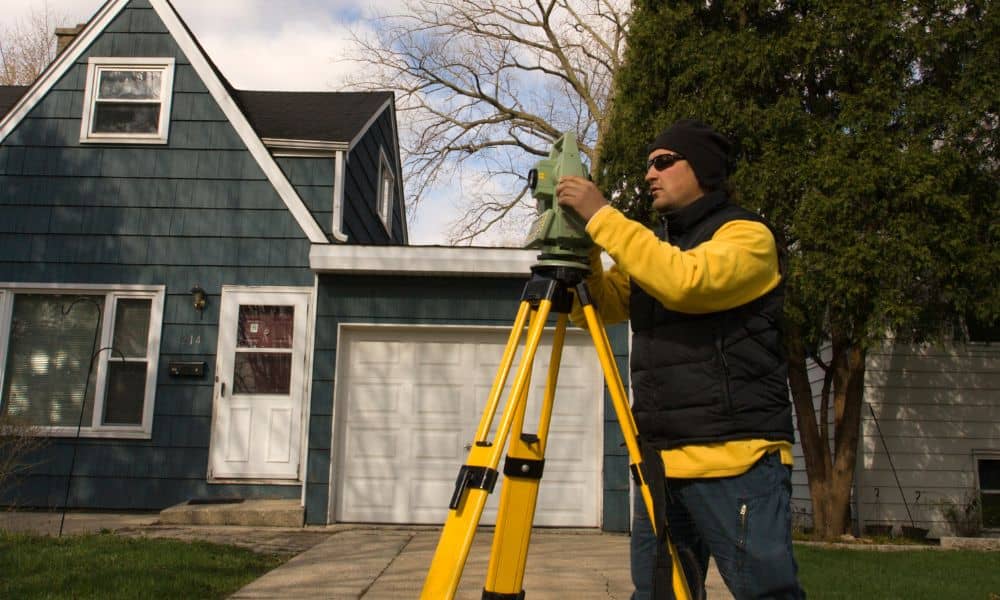
A loan closing survey is a professional drawing of your property that maps out its exact boundaries and physical features. Licensed surveyors measure the land, locate improvements like homes, garages, or fences, and note easements or rights of way.
Think of it as a snapshot of what you’re actually buying. While a deed gives the legal description, the survey shows you how that description looks on the ground. For buyers, this step helps confirm that the property matches the paperwork.
Why Every Homebuyer Needs a Loan Closing Survey
When you’re investing in a home, you want peace of mind. A loan closing survey does exactly that by answering important questions:
- Are the property lines where you think they are?
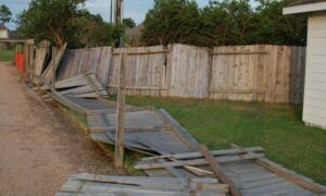
- Does the neighbor’s fence or shed cross onto your lot?
- Are there easements that might limit where you can build a pool or addition?
- Does everything line up with what the seller and lender promised?
In cities like Houston, where neighborhoods mix historic homes with new builds, surprises happen more often than people realize. Without a survey, you might not discover an issue until after closing—when it’s too late.
What Does a Loan Closing Survey Show?

While details vary by property, a loan closing survey usually includes:
- Property boundaries – the exact outline of your lot.
- Structures and improvements – homes, garages, driveways, fences.
- Easements – rights granted for utilities, drainage, or access.
- Encroachments – any structures that cross a boundary line.
For homeowners, drainage easements are a common feature since the city deals with heavy rain and flooding. Knowing about these before you buy helps you plan and avoid disputes later.
When Is a Loan Closing Survey Required?
Most lenders and title companies require a loan closing survey before approving a mortgage. They want assurance that the property is exactly what the documents say it is. This protects not only them, but also you as the buyer.
That said, even if your lender doesn’t make it mandatory, it’s still a smart move. Skipping the survey might save you a few hundred dollars upfront, but it could cost thousands if a boundary issue or easement problem arises later.
Clearing Up Common Misconceptions
A lot of buyers confuse a loan closing survey with other parts of the home-buying process. Let’s clear that up:
- It’s not the same as an appraisal. An appraisal estimates value; a survey confirms boundaries.
- It’s not just paperwork. It’s a legal document that can prevent major disputes.
- It’s not always optional. A title survey for closing is often required by lenders, but even if yours doesn’t ask for one, getting it done can give you peace of mind.
How Much Does a Loan Closing Survey Cost?
The cost of a loan closing survey depends on property size, complexity, and location. A small lot in the suburbs might be less expensive than a large property with multiple structures. While prices vary across the country, most surveys fall within a few hundred dollars.
In Houston, where land records and neighborhood layouts can be complicated, investing in a survey is especially worthwhile. Compared to the overall cost of buying a home, the survey fee is minor, but the protection it offers is major.
Tips for Ordering a Loan Closing Survey
Here are some simple steps to make the process smooth:
- Hire a licensed local surveyor. A professional familiar with your city’s rules and land conditions will save you time and stress.
- Ask about turnaround time. Closing deadlines can be tight, so make sure the survey will be ready when you need it.
- Review the survey yourself. Don’t just file it away—look at it and ask questions if something seems unclear.
- Keep it safe. You’ll likely need it again if you build, sell, or face a boundary question in the future.
Final Thoughts
A loan closing survey may not sound exciting, but it’s one of the smartest moves you can make when buying a home. It gives you clarity about your property, prevents disputes, and reassures your lender that everything checks out.
For homebuyers across the country, where property lines and easements can be tricky—a loan closing survey isn’t just another box to tick. It’s your safeguard. When you walk into closing, you’ll know exactly what you’re buying, and you’ll walk away with confidence in your investment.