Houston is buzzing after news broke that nearly nine acres of Hermann Park could be taken for a hospital expansion. At the center of this heated debate is something most people don’t think about until they buy a home or face a dispute: the property survey. This simple but powerful document draws the line—literally—between what belongs to you, your neighbor, or even the city. In the case of Hermann Park, those lines may decide whether treasured green space stays public or turns into hospital buildings.
What a Property Survey Means in a Public Land Dispute
Most people think of a property survey as a tool for private homeowners—something you order before closing on a house or putting up a fence. But in eminent domain cases, like the Hermann Park fight, surveys take on a different weight. They aren’t just records; they’re evidence.
Surveyors measure and map the exact boundaries of the land in question. They identify how much acreage is being taken, whether any improvements like paths or utilities fall inside the affected area, and how those lines line up with existing plats and deeds. Without a survey, courts and city officials would have nothing concrete to rely on when making decisions about compensation or land use.
Think of it this way: when a park becomes a plot, the first step isn’t building—it’s measuring.
Why Is a Wake-Up Call for Property Owners
Eminent domain cases feel far removed from everyday life. After all, not everyone owns land next to a major hospital or public park. But the truth is, Houston’s growth often leads to projects that nibble at private property—whether it’s road widening, utility upgrades, or flood control work.
That’s where a property survey becomes essential. It doesn’t just protect your backyard from neighbor disputes. It also guards against surprises when the city or county comes knocking. The Hermann Park case shows that even a beloved public green space is not immune to boundary lines being redrawn. If it can happen to a landmark, it can happen in your neighborhood too.
How Property Surveys Draw the “Take Line”

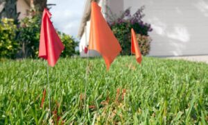
In the Hermann Park case, surveyors will play a crucial role in defining the “take line.” This is the boundary that separates what stays public and what gets absorbed by the new hospital project. It sounds straightforward, but in practice, it involves deep research and careful measurements.
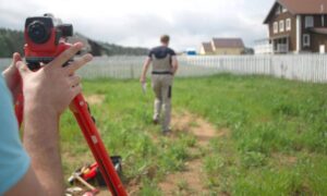
Surveyors review old plats, deeds, and legal descriptions to confirm where park property begins and ends. They measure the land on-site, sometimes uncovering monuments or markers set decades ago. Then they prepare maps that overlay the proposed acquisition area with the existing property lines.
For the public, these survey maps look like lines and shaded boxes. For lawyers, city planners, and judges, they are the blueprint for legal decisions and financial settlements. The more precise the survey, the less room there is for dispute.
Lessons for Homeowners
So, what does a battle over Hermann Park teach the average homeowner? First, it reminds us that property rights are only as strong as the documentation behind them. If a surveyor hasn’t confirmed your boundaries, you’re relying on assumptions.
Second, it shows that surveys aren’t just paperwork. They’re living records that protect you when land use shifts. For example, if the city needs part of your yard for a drainage easement, a property survey will spell out exactly how much land is affected and what you’re entitled to in return.
Finally, it highlights the importance of keeping surveys current. Houston is a city that never stops building. Roads are widened, new developments pop up, and flood control projects reshape neighborhoods. Having an updated survey means you know where you stand—literally—before change arrives.
The Civic Side of Surveying
Most property surveys are private transactions, tied to home sales, mortgages, or construction. But public projects highlight their civic importance. Without surveys, governments couldn’t fairly expand hospitals, parks, or roads.
That said, the Hermann Park case also raises questions about balance. Who decides when public benefit outweighs private or community loss? While surveys won’t answer that moral question, they ensure the debate starts with facts. Everyone—residents, city leaders, hospital planners—looks at the same map and the same measurements. From there, the fight moves to courts and council meetings, but at least the ground truth is clear.
Checking Your Own Property Records
You don’t need to wait for a dispute to see where your land stands. In Houston, homeowners can look up plats, right-of-way maps, and easement records through the Harris County Clerk or the City of Houston’s online plat tracker. If you suspect your property may be near future projects—like along the Texas Medical Center, Museum District, or flood control zones—it’s worth pulling your last survey.
If it’s more than a decade old, or if you’ve added improvements like fences, garages, or driveways, it may be time to order a new property survey. The cost is small compared to the value of knowing exactly where your land begins and ends.
Why This Story Matters Beyond Hermann Park
The Hermann Park dispute has sparked strong emotions because it pits health care growth against community green space. But beneath the politics is a lesson for every property owner. Land isn’t static. It shifts in use, ownership, and regulation. The only constant is the surveyor’s map, the line in ink that becomes the line in law.
Whether you own a bungalow in the Heights, a townhouse in Midtown, or a lot near the Medical Center, your property rights rest on the same foundation that’s guiding the Hermann Park debate: the property survey.
Final Thoughts
The fight over Hermann Park shows how a few lines on a survey map can redefine a city landmark. For property owners, it’s a reminder not to take those lines for granted. A property survey isn’t just a document—it’s your safeguard when the city expands, when boundaries are challenged, and when new projects put your land at risk.
In Houston, where growth is constant and land is precious, knowing your boundaries is more than peace of mind. It’s protection, security, and the starting point for every decision about your property.