If you’re knee-deep in a commercial real estate deal and someone mentions an “ALTA survey,” you might be thinking… Do I really need that? Or is it just another box to check (and pay for)?
Let’s break it down—without the jargon—so you know exactly what an ALTA survey is, when it’s required, and whether it’s something you should be budgeting for.
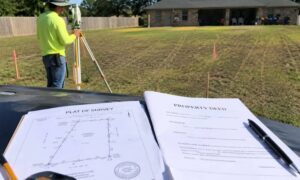
📌 What Is an ALTA Survey, Anyway?
An ALTA/NSPS Land Title Survey (yeah, it’s a mouthful) is basically the gold standard of land surveys—especially for commercial real estate. Think of it as the ultra-detailed version of a boundary survey. It doesn’t just show where your land starts and ends—it uncovers legal, structural, and zoning details that matter when money, contracts, and development are involved.
This type of survey is designed to meet standards set by two major organizations:
- ALTA (American Land Title Association)
- NSPS (National Society of Professional Surveyors)
🏢 Who Actually Needs One?
ALTA surveys aren’t for everyone. You probably won’t need one if you’re buying a single-family home in a quiet neighborhood. But if you’re involved in commercial or industrial property, there’s a good chance it’s required—especially if a lender or title company is involved.
Here’s who typically gets one:
- Commercial property buyers or investors
- Title companies issuing title insurance
- Banks or lenders offering financing
- Real estate attorneys handling closings
🔍 What’s in an ALTA Survey?
A lot more than lines on a map. ALTA surveys include:
- Property boundaries
- Building locations
- Easements (like shared driveways or utility access)
- Encroachments (like a neighbor’s fence creeping over)
- Flood zones, zoning classifications, and more
- Optional features from “Table A” (things like underground utilities or parking counts)
It’s basically the full story of the land, above and below.
💡 Why Would You Need One in Houston?
Here’s where it gets local. If you’re dealing with Houston real estate, an ALTA survey is often not optional—especially for larger properties or anything near oil easements, drainage zones, or flood-prone areas (which Houston has plenty of).
The city’s mix of new developments, old plats, and complex zoning means ALTA surveys are a must-have for due diligence. Title companies and lenders in Houston often require them to make sure everyone’s protected.
But—if you’re buying a simple residential lot or no financing is involved, a standard boundary survey might be enough. Always check with your title company first.
⚖️ Legal + Financial Peace of Mind
An ALTA survey isn’t just about knowing where your fence should go—it can:
- Prevent future lawsuits over encroachments
- Help developers plan properly before breaking ground
- Support your case in court if there’s a boundary dispute
- Make sure your title insurance actually covers the property you’re buying
💸 What’s It Going to Cost Me?
They’re more expensive than basic surveys—because they’re more detailed.
Here’s a ballpark:
- Small commercial lot: $2,000–$4,000
- Larger, complex sites: $5,000–$10,000+
- Rush or tough locations (like wooded or flood-prone areas): Even more
Plan for about 1–3 weeks to get the final report.
✅ How Do You Find the Right Surveyor?
Not all surveyors offer ALTA surveys, so make sure yours:
- Is licensed in Texas
- Has experience with ALTA/NSPS standards
- Knows Houston’s quirks (easements, flood zones, city rules)
- Can clearly explain what’s in the survey report
Ask for examples of past work or Table A options they typically include.
Final Thoughts: Worth It or Not?
If you’re buying or selling commercial property, especially in Houston, an ALTA survey is more than just helpful—it’s usually required. It gives everyone peace of mind and helps avoid serious headaches down the line.
But if you’re working with a small residential lot or a cash deal, and there’s no bank or title insurance involved? You might not need it.
When in doubt? Ask your title company or real estate attorney. They’ll let you know what’s really necessary—and what’s just overkill.